GPS Clock Rollover – Will my Satnav work after the 6th April?

models were quite large and came at a huge cost of over $2,000. Since 1991, GPS receivers have become much smaller and now built into many everyday items including phones, tablets and satellite telephones such as those made by Iridium, Thuraya and Inmarsat. GPS is also used by some IT systems as a reference point for accurate time.

Old GPS from the 1990’s

The clock system used by the GPS system is completely different to the time format of hours, minutes and seconds we all use. On April the 6th, 2019, the clock system used by GPS will reach its highest number and will the roll over to zero and start again. This is very similar to the computer clock problem which was known as the Millennium Bug or Y2K.

Recent press reports have hyped up the GPS roll over as a big problem. One executive from Trend Micro stated at a conference recently that he will not be flying on the 6th April. So do we have a problem? Absolutely not. We have been here before as the GPS clock system last rolled over in 1999 with no major problems created. Planes did not fall out of the sky, and everybody’s sat-nav did not stop working. So in this article, I am going to explore the science between the GPS clock and explain what we will all remain safe and why GPS technology will keep running.

GPS depends upon its clock system

The GPS systems uses accurate atomic clocks for a time reference. Time is used to calculate distance based on the speed that radio waves take to travel from  the satellites to GPS receiver. A minimum of four satellites are needed to calculate a three dimension fix  (Latitude, Longitude and Altitude).

As GPS needs highly accurate time keeping, the time signals from the GPS system is also used by IT systems as a time reference. One example of this in action is the computer systems used to trade stock and shares around the world.

The GPS system is digital which means that data is managed using binary code (ones and zeros). Days, Hours, Minutes and seconds is a format which does not work in computing, so binary counters are used to measure time in a different format which is easier to use. Software on the GPS units convert the GPS binary time to the normal format we all use.

The counter used to measure weeks is known as “10 bit binary” which means that a maximum 1024 weeks are counted before the counter is goes round the clock and back to zero. The GPS clock started in 1980 and the first time the counter reached its maximum count took place in August 1999. There were no major issues back then.

Does the clock roll over present a risk?

Several newspapers in the UK has published some alarming articles predicting disaster. The SUN is one example of scaremongering which has no scientific grounding. Many responsible commentators have added comments to some of these news articles questioning the poor content written by people who do not have any idea about the technology. The truth of the roll over is this – The GPS system will continue to operate and nobody has any reason to worry! So here is the reality check:

  • SatNav and other systems using GPS technology will stop working?  Untrue!  The clock rollover occurred in 1999, GPS manufacturers have been aware of this issue for a long time and have built function into the design of systems to cope with the rollover. It is unlikely that anyone will have an issue with a GPS purchased anytime over the past 5 years or more.
  • Some leading commentators have said that there could be issues with flights and other forms of transport?  Untrue! Ships and aircraft use multiple technologies to navigate in addition to GPS. Many modern satellite communications also use the Chinese and Russian navigation systems as well as the USA GPS system.
  • Cell phones and satellite phones will stop working as they lose their time reference? Untrue!  Phones normally get their time reference from the communications network. Some modern phones also include the Russian and Chinese versions of GPS,

Conclusion:  Ignore the press hype which predicts doom and gloom. GPS will carry on working as normal. Most systems will have the capability to handle the roll over. For that extra reassurance, people can update the software (known as firmware) on older GPS receivers so they can be 100% sure that there will not be an issue.

How ICT can assist maritime search and rescue operations

Conflicts in the Middle East and Africa has led to a significant movement of people. Each week, thousands of people are risking their lives to reach Europe by attempting to cross the Mediterranean Sea. So far and estimated number of 3,000 people have already drowned this year. Save the Children and other NGOs have launched ships to rescue the many people who put to sea in unseaworthy boats. On board the rescue ships, the NGOs take care of immediate medical needs, provide food and water and transport the rescued people to a safe port in Europe where they will be looked after by the authorities.  

Technology has a very important role in support Search and Rescue (SAR) operations. Being on a ship has a lot of similarities to working in a remote field site ashore. Similar technologies are used, but there are also technologies used in such an operation which are unique to the marine environment. In this article, we will explore the technologies used to support SAR operations.

Operational overview
The movement of people from Turkey to Greece has significantly reduced due to the deal reached between the EU and the Turkish Government. Further west, the situation is very different as people leave the shores of Libya to attempt the long and treacherous journey to the Italy, Malta and other destinations. Save the Children, MOAS, MSF and other NGOs are running search and rescue ships under the coordination of the Italian Coastguard. This operation has become even more necessary as people traffickers are sending boats to sea of ever decreasing quality. In some cases boats are being sent with just about enough fuel to reach the areas where rescue ships operate.  

 The boats are often overloaded which means that getting people off them is dangerous and requires a lot of communication with the people on board in advance of rescue. NGOs are using cultural mediators who have the language skills to explain to people how to leave the boat safely. The main danger is capsize of the boat caused by all people on board rushing to the same side of the boat to be rescued.

It is now the peak season for migration as the sea is fairly calm. But rescue is still needed when weather conditions deteriorate as the boats continue to put to sea. The traffickers just sell off tickets at half price. People are taking huge risks as the likelihood of people coming to harm increases significantly in bad weather.  

Airborne Surveillance
moas_droneUnmanned Airborne Vehicles (UAVs) are being used by MOAS. In humanitarian work, we try to avoid the term “Drones” as military drones have been used in many places to fight wars. The use of UAVs is well established in disaster response where small battery powered UAVs are used to gather aerial images.

MOAS has partnered with Schiebel and have two long range UAVs on the rescue ship. These UAVs are miniature helicopters with powerful engines running on aviation fuel. They are controlled from a ops room on the ship by trained pilots.

When on deployment, these UAVs will cover a large area of up to 100 miles from the ship. From the on-board cameras, boats needing rescue can be identified and locations shared with the Coastguard. Depending on the location of SAR ships, the nearest ship will be tasked to conduct a rescue. This could be the MOAS ship if it was the nearest.

Tracking the SAR FleetaisOn land, safety and security managers are often keen to know the whereabouts of vehicles on the road in places where the situation is insecure.  In maritime operations, there are also security risks to ships from threats such as piracy. There have been incidents reported by some  ships and as a result, most organizations involved in the effort have developed procedures to deal with such situations.  

Tracking the locations of ships is very easy and does not require much up-front investment in technology as any ship over 300 tons which operates outside of national waters is required to carry the Automatic Identification System (AIS) under the IMO SOLAS regulations. This requirement was introduced in 2002 and has been extended in some countries to cover national coastal and inland waters.  

AIS operates on the VHF radio frequency at a maximum power of 12.5W. Each ship transmits its location, speed, heading, identity and other information about the ship. The original intention of AIS was for collision avoidance (supplementing RADAR which displayed just displayed range and bearing of objects which reflected a signal). As the system was designed for the purposes of collision avoidance, the system was never intended by the IMO to be a long range tracking service. However long range tracking has evolved thanks for private sector and the internet .

AIS signals are in the public domain. It’s very easy to buy an AIS receiver for $100 and with some ingenuity, the data can be displayed on a google map. Some hobbyist have demonstrated this though setting up AIS websites which display live data from ships at sea. John Ambler created a google map for the busy waters surrounding the Isle of Wight on the south coast of England (see http://www.john-ambler.com/ais/google.html).

Commercial AIS tracking websites such as MarineTraffic.com have appeared and brings together a global network of people operating AIS receivers. Many of these sites are free to view, but for a fee, there are more advanced functions available. In recent years, low orbiting satellites have been equipped with AIS receivers so that ships can be located outside of the areas covered by the land based AIS stations. The AIS websites will normally charge a fee to access the Satellite AIS. As satellite AIS is evolving, there can be significant gaps of up to 8 hours between position reports.

Another benefit of using the “paid for” services is that organizations can mark out areas on the map so that operations can be informed about key events such as when a ship leaves port, arrives at its destination or enters into a specific area. In some operations, SAR ships will be required to keep a certain distance from the coast and only allowed to enter a specific area to conduct a rescue. Alerts can be set up to let operations staff know when such areas are entered.

Emergency & routine communicationsgmdss
Many NGOs have safety and security policies which require there to be at least two separate modes of communication. On land, this may include radio and satellite communications. Local mobile networks are sometimes included if they are considered to be stable enough. The main purpose of such policies is to enable teams to be able to call for help from specific trusted contacts. As NGOs take to the sea and conduct SAR operations, the need to reach out for help when the rescue ship itself encounters a problem is covered under the various laws and standards which regulates ships (flag state & IMO).

All commercial ships deploying to sea are required to carry equipment which complies with the Global Maritime Distress and Safety System (GMDSS). For many years, ships have been equipped with various types of radio. In the late 1970’s the worlds very first commercial satellite communications network INMARSAT was introduced to shipping and later on was adopted by NGOs and other sectors working ashore. The complex array of radio and satellite communications was managed by the ships radio officer.

In the 1990s. GMDSS was launched and became a game changer. As a new standard, GMDSS integrated all modes of radio and satellite communications into a single control console where routine and/or distress messages could be sent easily at the push of a button. The design of GMDSS systems meant that all communications could be handed by the bridge crew thus making the role of the Radio Officer redundant.

There is a well-established system at sea where as soon as a distress is sent by any vessel, nearby ships are required to assist if they are able (and it’s safe to do so). Every part of the worlds ocean is covered by a capable rescue authority which coordinates a range of rescue assets ranging from helicopters to warships. Where NGOs commission ships for SAR operations, they should consider the safety and security aspect of communications as outsourced to the ship’s crew as the GMDS system on board will most likely exceeded any requirement stated in the NGO’s policy.

For routine communications, NGO teams will need their own ways to communicate with their operations people ashore. Mobile phone networks are fine for when the ship is alongside, but out at sea, satellite communications will be required for when the ship moves beyond mobile phone coverage which is typically limited to 10KM or less from the coast. Save the Children have set up Iridium for its communications on its ship as Iridium external antennas are Omni-directional. For on-board communications between the team, short range UHF radios are used which are set up on IMO frequencies designated for on-board use.
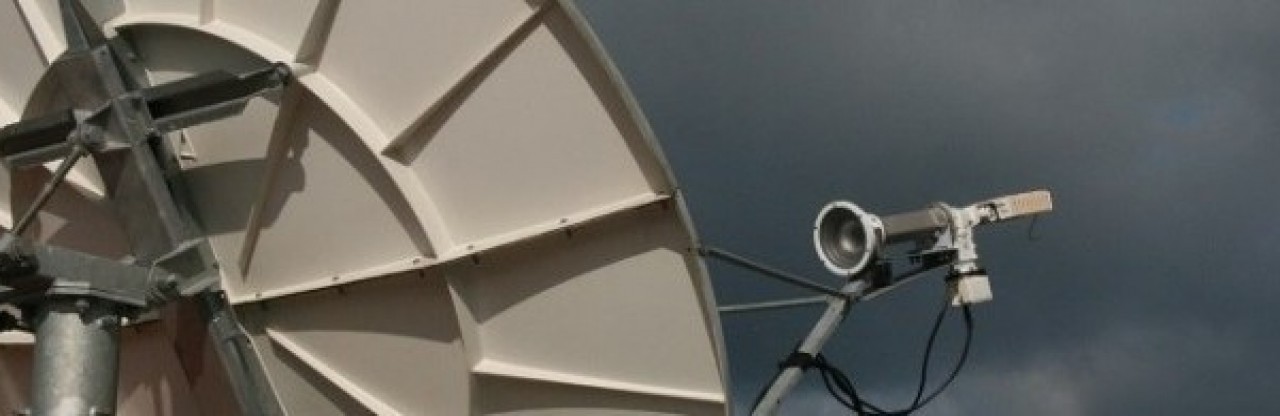
Internet accesskvhAt sea, access to the internet is just as important as it is on land.  Whilst in harbour, it’s easy to connect to internet services provided by mobile networks. Further offshore the internet needs to be provisioned through satellite services such as VSAT. On land, a VSAT dish is fixed to the ground and pointed at the satellite, shore based systems typically cost $4500. At sea, the ship is constantly moving which means more complex technology is required to keep the VSAT dish pointing at the satellite. If the dish is misaligned by anything greater than ½ degree, the signal is lost and internet fails.

Marine VSAT systems are much more expensive due to the technology involved. Typically the budget systems start out at $20,000 for the hardware. They tend not to track satellites very well in rough seas. If there is a high dependence on internet access, more robust and expensive systems costing as much as $40,000 will be needed. On top of this, there will be the monthly usage fees.

The technology is also quite expensive and complex to install. The larger systems need special consideration as the antennas and their protective domes  weigh a lot and installers need to work closely with the ship owners as these systems will have a minor effect on the overall ship’s stability.  

Save the Children  chartered a vessel which already had a VSAT installed. The KVH system is at the low end of the technology and limited to 1MB capacity which costs $4,000 a month to run. For the 12 crew on board, this is sufficient and the crew have been able to access online resources such as health information systems, email, conference calling and a tool used to collect information about the people rescued.  Many organizations are using tablets and Kobo software to collect anonymous information about the people rescued.  

Weather forecastingmet-office

Mariners are well trained in meteorology and its normal for ship crews to be able to access local weather information. As part of the GMDSS infrastructure, various coastal stations and coastguards broadcast weather forecasts several times a day. Weather information is also transmitted to GMDSS text based systems such as Navtex and Inmarsat C safety net. Generally these forecasts are limited to a 48 hours forecast window and covers a wide area.  

Save the Children is sourcing weather information the UK Met office. The forecast format provides a 5 day outlook. A fresh forecast is generated every 12 hours and sent directly to the ship by email. The forecast is for a specific location near to where rescues take place and gives the team information about predicted wind, wave and swell height. The format of the forecast was designed for the oil industry and includes wind data for a height of 100m above sea level – quite useful information for the MOAS UAV operators.

Good quality weather predictions could enhance the efficiency of the rescue operation. If sea conditions are predicted to worsen for a few days making it impossible to rescue, ships could use the downtime to return to port and replenish fuel etc.

Lessons learnt
​NGOs entering SAR operations may not have maritime experience at all, if they take the same approach to providing similar technology to what would be used on land, budget holders will be completely shocked at the complexities and costs of setting up the required technologies. It is really important that programme managers engage technical experts from the get go, preferably well before budgets are set. Technology at sea is a very specialist area which means that organizations may  need to look beyond their internal ICT teams if they do not have in house maritime expertise.

Exploring GIS and data collection.

“GIS” is a term used very frequently within the humanitarian sector and stands for Geographical Information System. For many, this conjures up the image of very complicated IT systems. GIS can be a very complex science as it’s the place where maps and big data will meet. In this article, I n this article, I am going to put the potlight on GIS as a concept and explain what GIS is all about. I will also point you in the direction of resources where you can try out GIS for yourself.

GIS is not new
osMaps have been in existence for centuries and defined in some dictionaries as “A representation of the earth’s surface or part of it” Maps are more complex than this definition as they go well beyond simple aerial photographs. When drawn in graphical form such as the UK map (left), information can be added about the features. Contours show how steep the hills are, the red shade shows land which belongs to the army and dangerous to enter. Symbols are used to identify items of interest such as a public telephone. A map is therefore graphical information in its own right. Before the computer age, the Graphical Information  System would possibly have been a filing cabinet of information which would be used by map makers to make up the maps such as the ordnance survey maps used in the UK.air map

 Maps such as ordnance survey are made for mass production and often referred to as base maps. There are many specialists professions who require specific information to be added to maps .The Aviation industry is a good example where information regarding flight paths,  no-fly zones and airfield approaches are overlaid onto standard maps so that pilots can find their way around.


How technology disrupted map making
Specialist maps which contain additional information have mainly been limited to certain professions and would have been expensive to produce due to short print runs. The process of adding additional and new information would be a combination using ink to write new information onto a map, and a method to provide feedback to the original mapmaker so that new information could be included in the next edition of the map. Advances in printing technology and computerised mesriapping systems has enabled maps containing very customised information to be produced on demand.  Large format printers and GIS software has brought the art of mapmaking from the large map makers straight to places where maps will be used. One prime example of where maps are needed in a hurry is during disaster relief.

ESRI is one of the worlds leaving GIS systems and provides software either as an online system or as software loaded directly on a computer.

GIS in actionnargis map
A good GIS system will have a collection of base maps to which data can be added. Any form of data can be added to maps to be represented as graphical information. In large scale emergency responses, organisations such as MapAction will often deploy GIS volunteers from the mapping industry to create the many maps which will be required as part of the response.   

Let’s look at an example;

 In 2008, Cyclone Nargis passed through SW Myanmar and affected the population in the delta. MapAction used a combination of satellite imagery and aerial photography to produce the map of the affected areas. The map to the left shows the areas affected by flood (illustrated by red shade) and the path of the cyclone (blue line).

In any emergency the initial maps will display basic information about what damage has been done and what populations have been affected. This information is vital for emergency response organisations as they will be able to use the maps to make decisions about where relief efforts need to be focused.

As the response develops, coordination bodies such as UN OCHA, national and local government will require “WWW” information (Who is providing assistance, Where they are working and What services they provide).

Data can be a challenge
The key challenge faced by map makers is the wide range of data formats people use for different purposes. The basic data about who is doing what and where, is normally the starting point a later on, other people will begin to collect monitoring and evaluation data which can also be used to build maps.

 Whilst ESRI’s ArcGIS products have emerged almost as the industry standard tool to create maps, in the same was as Microsoft Word is the system of choice to create documents, the journey towards identifying a suite of tools for collecting data is still being made. Data collection is recognised as an issue and each year, new initiatives are launched to solve the issue. The problem is that many of these initiatives are looking at the same set of issues. I feel that it would be more fruitful if the various organisations looking at data collection could start to work together in order to define a new standard for data collection and create a suite of tools to collect it?

Does ESRI have the solution?
Amongst the many data collection initiatives ESRI launched a new smartphone application to collect data. The app is available for android and apple smartphones collectorand tablets. The new app is called “Collector for ARGIS” and can be configured with forms to collect information for ARCGIS maps. This new app was launched using lessons learnt by ESRI during the Ebola crisis in West Africa.

The screenshots below shows a form used to collect information about damage to properties and how families were affected by an Earth quake. If the smartphone is online, the data is immediately sent to ESRI servers for so that people can see the most up to date situation as data is collected by people on the ground. The apps also work offline and will store data until the field teams reach a place where they can connect to the internet and upload data

Try it for yourself
GIS is the place where data meets mapping. ESRI is often considered as the “Swiss Army Knife” of GIS systems has it has so many tools available.  Argis Online (http://www.esri.com/software/arcgis/arcgisonline), is an internet resource where it’s possible for people to create their own maps and share them with others. Anyone can sign up with a Public account which allows people to create basic maps. Public accounts have limited features but it’s possible to create maps and manually overlay text and shapes. A fully featured account includes many data tools. It’s possible to explore the advance functions by signing up for a 60 day trial. In the example below, a map has been created which shows expected radio coverage from two radio stations.

chad map

Conclusion
Whilst GIS is a well-established discipline with ESRI considered as the leading system, there remains some challenges around the task of collecting data. I would like to think that the new ArcGIS collector is showing some promise and as it is designed by ESRI, the prospect of a standard turnkey system which collects data and produces the same maps will make the art of GIS a lot more efficient. ESRI has a global footprint of resources which means that support is available in most places and in many languages. There is also a massive amount of online training materials to support ESRI products – much of it free of charge.

How what3words will change the way we use addresses globally

Before starting out in the ICT profession in 1999, I spent many years at sea on various ships, yachts and a submarine. The art of navigation was a major part of my work as I plotted a safe course from port to port. Many years later, in the NGO sector, I am still very much involved in navigation, but from a technology viewpoint. In past articles, I have covered various navigational topics which have explored GPS solutions. In this article I want to share with you a great concept which resolves a long standing issue of providing an easy to remember or to communicate addressing system. The solution is so simple and brilliant, when I learned about it this week, it just blew my socks off !!!!!!

Postcode Chaos
In the UK, we have a postcode system which can be used to locate places. The format use consists of 6 characters for much of the UK or if you live in London, its 7. The postal code for Save the Children Office is WC2H 7HH. If were to put this code into Google Maps, you would get a very accurate location of centre.
map1

The UK post code system in the UK is very good for businesses as the code not only defines the actual building location, but also which floor the business is on. However for domestic residents, it’s a different story. Every time I send my postcode to a taxi firm, the driver uses my postcode to find my house using a satnav. This causes a problem as the UK postcode system sends the driver to the other end of the street. The driver sometimes gets lost and needs to call me to find my location 

Where postal or Zip codes do not exists
As imperfect the UK postal code system might be, it’s better than having no postcode at all. In Monrovia, Liberia, there are street names, but no postal codes or numbers. The address of the office which was used by one NGO was “Between 15th Street and 16th Street, Russell Avenue, Sinkor, Monrovia.

As there are a number of premises between  15th & 16th streets, this is an excuse for DHL to loose parcels!
Map2

How do we deal with remote places where there are no street names?  How can we accurately locate individual families in a refugee camp?  Latitude and Longitude is a long established method to locate things very accurately. In colonial times, Longitude was problematic as many nations centred “Zero Degrees” Longitude on their capital cities. This meant that if longitude provided in in the French format were to be plotted on a British map, the difference in formats would result in an error which would be more than 100KM.

These days we use a global format for Latitude and Longitude, but there are still issues. Latitude and longitude can be presented in a number of formats. With the emergence of internet technologies Latitude and Longitude is represented in a digital format. Traditionally position was expressed as Latitude followed by Longitude, but some technologies such as Google maps will express position in the opposite order e.g. -1.682017, 29.231105.

Whilst Lat/Long can be highly accurate, there is a great potential for error. Errors can also result when people try to communicate location in this format. Get one digit wrong in this format, and people will simply show up at the wrong place.

World class addressing system
Let’s be clear, the use of latitude and longitude is going to continue to be the primary means which technology will use for navigation, but it’s not user-friendly, What we need is a new global system where people can express to others any location on the planet in a very simple and easy to use way. In London, UK, a new start-up organization has found the answer. It’s called what3words. They have a very simple concept that every location on the planet can be expressed with just three words. It’s pure genius and as an old navigator, this idea simply floats my boat. In my line of work I see a lot of innovation, but this ideal is dynamite. The grid resolution of this addressing system is so fine that each unique address covers a box of 3 meters square. By using this system, not only does an office have an address, it is possible direct people to the correct entrance !

Read More